Institute | Training
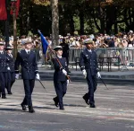
IETA military engineering students training at ENSTA marched in the July 14 parade
IETA military engineering students training at ENSTA marched in the July 14 parade
About 40 IETA military students marched on July 14, 2026, on the Champs-Élysées on behalf of ENSTA and the DGA. For the past three weeks, they had been preparing together for this major event for the French armed forces, whose theme was “Europe’s...
About 40 IETA military students marched on July 14, 2026, on the Champs-Élysées on behalf of ENSTA and the DGA. For the past three weeks, they had been preparing together for this major event for the French armed forces, whose theme was “Europe’s...
, was severely affected by seismic wave amplification. Credit: United States Geological Survey")
")